- Information on accommodation, public transport, seasonal closures and tidal restrictions
- Twelve day-walk chapter sections with detailed route descriptions and full Ordnance Survey mapping
- Fascinating notes on points of interest
-
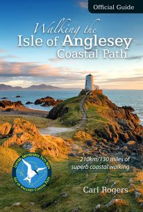 The Official Guide to the Isle of Anglesey/Ynys Mon Coastal Path New Edition - rewalked and wholly updated. The route is described in a clockwise direction, starting and finishing at Holyhead. The 130 mile/210km long Isle of Anglesey Coastal Path passes through some of the grandest coastal scenery in Wales — wide sandy bays and estuaries, intimate coves, dramatic cliffs and rocky islets, sand dunes and forests—much of it designated ‘An Area of Outstanding Natural Beauty (AONB). This Official Guide has been designed to provide all the information needed to plan and walk the coastal path and includes:
 -
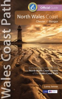 New Edition - rewalked and updated 2022 One of seven Official Guides to the Wales Coast Path The 80 mile/125km long North Wales Coast section of the Wales Coast Path between Chester and Bangor runs alongside the broad Dee Estuary and traditional seaside towns past Conwy Castle, the Great Orme, Penmaenmawr and Conwy Mountain to the university town of Bangor on the Menai Strait. This Official Guide splits the route into 8 convenient day sections, each of about 9-12 miles / 14-20 kilometres. It contains everything local and long-distance walkers need to enjoy the path.
 -
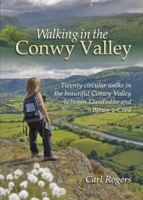 Twenty circular walks between Llandudno and Betws-y-Coed, in and around the beautiful Conwy Valley in eastern Snowdonia.
 -
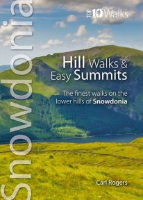
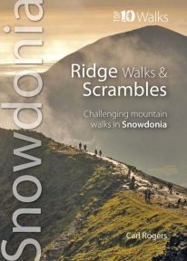 The ten routes outlined in this attractive pocket size book are amongst the very best challenging routes on the mountains of Snowdonia. Snowdonia's mountain ridges can be every bit as dramatic as the summits they connect. Some are well known classics like the Snowdon Horseshoe or Nantlle Ridge, while others are surprisingly well kept secrets like the Llech Du Spur, Gyrn Lâs Ridge or the ridges of the northern Glyderau. Created as a companion volume to the best selling 'Top 10 Mountain Walks', these little books will show you the very best that Snowdonia has to offer.
 -
Coming Soon
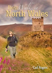 This authoritative walking guide will take you to some of the very best, tried-and-tested circular walking routes across NorthWales. The book covers walks in Anglesey, the Lleyn Peninsula, Snowdonia, the Conwy Valley, the Clwydian Range, and the Vale of Llangollen.
 -
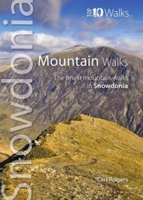 The hills and mountains of Snowdonia will captivate any lover of wild mountain scenery, with around 100 summits above 2,000 feet (approximately 610 metres) and fourteen exceeding 3,000 feet (914 metres). The ten classic walks in this great little guide have been chosen to give a variety of routes, spread across the entire National Park, with most of the main hill groups represented. For each mountain the most scenic route has been chosen and where possible these are well-established, classic paths, easy to follow, with good access and official parking. Enjoy Snowdonia.
 -
 One of a series of four books for Snowdonia in the popular Top 10 Walks series. Handy, pocket-sized, full colour walking guides written by experts. The perfect impulse buy. Free display stands available. Other titles in the series include: Mountain Walks, Ridge Walks & Scrambles and Pub Walks. Uses Ordnance Survey mapping.
 -
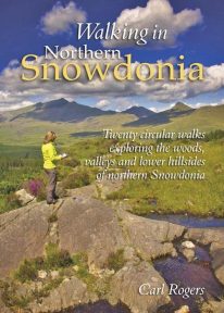 This attractive book explores twenty of the best low level circular walks in northern Snowdonia. Walking in Northern Snowdonia is dedicated to the northern half of the National Park, bounded by the Conwy Valley to the east, Glyn Lledr and the Vale of Ffestiniog to the south and Cwm Pennant to the west. Twenty circular walks are described, ranging in length from 4½ to 9 miles, which explore the woods, valleys and lower hillsides of this unique and beautiful area.
 -
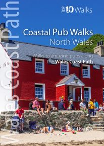
North Wales' best coastal pub walks
The comfortable, friendly and often upmarket pubs along the North Wales coast complement the walking on this superb stretch of the Wales Coast Path. Each walk incorporates a section of the Wales Coast Path, and starts and finishes close to a great, carefully selected pub. Combined, they cover the very best stretches of North Wales' coastline, one of striking contrasts and wonderful surprises. The easy, circular pub walks take in the North Wales Coast between Chester and Caernarfon, the Isle of Anglesey, and the remote Llyn peninsula. All the pubs are situated either right on the coast or a short hop inland — some in coves and harbours, some in the dunes or close to clifftops, others almost on the sand — and the majority are open all day. With the pubs often open all year and the walking good in all seasons, the North Wales Coast, Anglesey and the Llyn are quite rightly a year-round destination. -
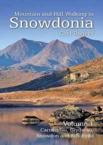 Mountain and Hill Walking in Snowdonia is a two volume in-depth guide to every summit of note in the Snowdonia National Park. Each recommended route is described in detail and accompanied by a full colour relief map. All the routes are circular and include information on parking, distance and height gained. Volume 1 covers the northern half of the National Park.