-
Coming Soon
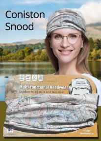
Lake District: Coniston - Neck Gaiter/Scarf/Snood
Wearable large-scale 1:25,000 Ordnance Survey map artwork: Coniston in the Lake District
CONISTON IS ONE OF THE LAKE DISTRICT'S LOVELIEST LAKES. Over five miles long and surrounded by the Cumbrian fells, Coniston is a justified favourite with visitors. The luxurious, silky neck tube features wearable large-scale 1:25,000 Ordnance Survey map artwork. Now you or a friend can own this stylish and permanent souvenir of an iconic part of the English Lake District. Note: While the Ordnance Survey mapping used on the snood is up-to-date at the time of production, it is not recommended for navigation. Walkers should carry the correct OS online or sheet map and compass.Ordnance Survey Licence No.: 0100047867
-
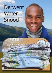
Lake District: Derwentwater - Neck Gaiter/Scarf/Snood
Wearable large-scale 1:25,000 Ordnance Survey map artwork: Derwentwater in the Lake District
DERWENT WATER IS ONE OF THE LAKE DISTRICT'S MOST POPULAR LAKES. Surrounded by fells, the island-dotted lake is three miles long and lies just to the south of Keswick. This luxurious, silky neck tube features wearable large-scale 1:25,000 Ordnance Survey map artwork of the lake and its beautiful shore. Now you or a friend can own this stylish and permanent souvenir of an iconic part of the English Lakes. Note: While the Ordnance Survey mapping used on the snood is up-to-date at the time of production, it is not recommended for navigation. Walkers should carry the correct OS online or sheet map and compass.Ordnance Survey Licence No.: 0100047867
-
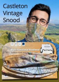
Peak District: Castleton (Vintage) - Neck Gaiter/Scarf/Snood
Wearable large-scale historic map artwork: Castleton in the Peak District
CASTLETON AND THE GREAT RIDGE LIE AT THE HEART OF THE PEAK DISTRICT NATIONAL PARK. The ever-popular town lies between the gentle limestone 'White Peak' to the south, and the starker gritstone 'Dark Peak' to the north. This attractive, silky smooth snood features historic coloured map artwork showing the area in detail. Note: The historic mapping used on this snood is not recommended for navigation. Walkers should carry the correct modern OS online or sheet map and compass. -

Wales: Cadair Idris - Neck Gaiter/Scarf/Snood
Wearable large-scale 1:25,000 Ordnance Survey map artwork: Cadair Idris in Snowdonia
CADAIR IDRIS IS THE SECOND-HIGHEST MOUNTAIN IN THE SNOWDONIA NATIONAL PARK. Rightly popular with walkers, it stands at the southern end of the National Park near Dolgellau. This detailed Ordnance Survey mapping snood shows the shapely mountain and its three main routes of ascent, making it the ideal present or souvenir for everyone who has climbed, or dreams of climbing, this wonderful summit. Note: While the Ordnance Survey mapping used on the snood is up-to-date at the time of production, it is not recommended for navigation. Walkers should carry the correct OS online or sheet map and compass.Ordnance Survey Licence No.: 0100047867