-
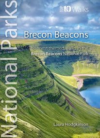 by Laura Hodgkinson This good looking, modern walking book will take you on ten short circular themed walks across South Wales' ever-popular Brecon Beacons National Park. The Brecon Beacons was Britain’s 10th National Park, established in 1957 to preserve and highlight the unique landscape of the area. The Brecon Beacons are said to be named after the historical practice of lighting beacons of fire upon hilltops to forewarn neighbouring valleys of invasion. The Brecon Beacons cover 1,344 square kilometres / 519 square miles with it’s spectacular waterfalls, valleys and expanse of hilly terrain; the Black Mountain to the west, the Fforest Fawr Geopark, Waterfall Country and the Pen y Fan range at the centre, and The Black Mountains to the east. The variety of flora and fauna is as vast as the landscape. Rare sub-arctic, alpine plants thrive within this unique climate. Mammals you're likely to spot include include wild mountain ponies, horseshoe bats, otters and water voles. Often seen birds of prey include the buzzard and iconic red kite. It's a wonderful area for walking and for everyone with a love of the outdoors.
 -
Coming Soon
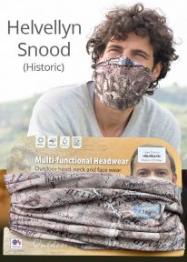
Helvellyn - Neck Gaiter/Scarf/Snood
Wearable large-scale historic map artwork: Helvellyn in the Lake District
HELVELLYN HAS BEEN A POPULAR CUMBRIAN SUMMIT FOR MANY YEARS. The snood's tightly woven material features a detailed historic colour map dating from 1912 — and shows the mountain in all its timeless beauty. A wonderful keepsake, gift or souvenir Note: The historic mapping used on this snood is not recommended for navigation. Walkers should carry the correct modern OS online or sheet map and compass. -
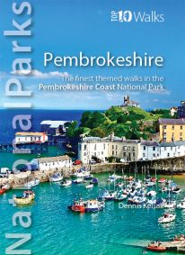 by Dennis Kelsall This superbly-written and good looking book will take you on ten short circular walks to the very best stretches of coast, pubs, tea shops, and viewpoints that the beautiful Pembrokeshire coast, in West Wales, has to offer. Defining the south-westernmost tip of Wales, Pembrokeshire’s coastline is arguably the most beautiful and varied in the British Isles. Virtually all of it lies within the Pembrokeshire Coast National Park. Relative isolation has left it largely untouched by modern development and most of its length is a wild frontier where the endless confrontation between sea and land is played out. Long stretches of coast face the fury of Atlantic storms and weakness and faults in the high cliffs are eroded into caves, coves and inlets. However, the harder rock, some of which is 700 million years old, resists the onslaught and stands out in rugged promontories and headlands. Elsewhere, sheltered landings and harbours, fine beaches and secluded bays reveal other aspects of this glorious landscape. In spring and summer the cliff tops break out in the pink, blue, white and yellow of countless flowers and sea crags are alive with nesting birds, while some of Britain’s largest seal populations arrive in autumn to give birth. It was this wild beauty that prompted the establishment of the Pembrokeshire Coast National Park in 1952. Despite being one of the UK’s smaller National Parks, it embraces a third of the county including all the offshore islands, the Daugleddau estuary, and the Preseli Hills. The Park is also home to the popular Pembrokeshire Coast Path — now part of the larger Wales Coast Path. Discover dramatic coastlines at St Davids Head and Strumble Head, Manorbier and Tenby. Climb to lofty coastal panoramas at Carn Ingli and Carn Llidi. Enjoy characterful waterside pubs at Porthgain and Cresswell Quay. Or relax over a quiet cup of coffee or tea and cake at two of Pembrokeshire’s cosiest and most welcoming tea shops and cafés. Unmissable.
 -
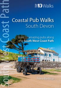
South Devon's best coastal pub walks
The lovely pubs along the South Devon coast complement the walking on this superlative stretch of the South West Coast Path. Each walk incorporates a stretch of the South West Coast Path, and starts and finishes close to a great pub. Combined, they cover the very best stretches of South Devon's coastline, one of great natural beauty and variety. The pub walks are ordered from west to east, starting at Noss Mayo on the Yealm estuary and finishing at Branscombe, near Beer. All the pubs are situated either right on the coast or a short distance inland — some in coves and harbours, others almost on the sand — and the majority are open all day. With the pubs open all year and the walking good in all seasons, the South Devon Coast is quite rightly a year-round destination. -
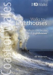 The ten walks featured here highlight the very best Welsh lighthouses and huge variety of the coastline of Wales. From vast expanses of sand, sea and sky, such as at Whiteford Point and Llanddwyn Island, to rugged coastline where seabirds wheel and skrike and porpoise and seals slide through the waves, like Strumble Head and South Stack, these walks to lighthouses guarantee a fine day out. All are circular, and vary from short and easy, like the to Talacre lighthouse, to longer and more demanding, such as that to St. Ann’s Head lighthouse — but none are beyond any reasonably fit and enthusiastic walker.
 -
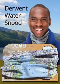
Lake District: Derwentwater - Neck Gaiter/Scarf/Snood
Wearable large-scale 1:25,000 Ordnance Survey map artwork: Derwentwater in the Lake District
DERWENT WATER IS ONE OF THE LAKE DISTRICT'S MOST POPULAR LAKES. Surrounded by fells, the island-dotted lake is three miles long and lies just to the south of Keswick. This luxurious, silky neck tube features wearable large-scale 1:25,000 Ordnance Survey map artwork of the lake and its beautiful shore. Now you or a friend can own this stylish and permanent souvenir of an iconic part of the English Lakes. Note: While the Ordnance Survey mapping used on the snood is up-to-date at the time of production, it is not recommended for navigation. Walkers should carry the correct OS online or sheet map and compass.Ordnance Survey Licence No.: 0100047867
-
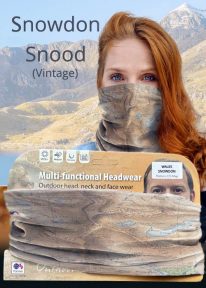
Snowdon - Neck Gaiter/Scarf/Snood
Wearable large-scale historic (1912) map artwork: Snowdon in Snowdonia
SOMETIMES CALLED 'THE TOP OF WALES', Snowdon is the highest and best-known peak in the country, reaching 1,085 metres (3,560 ft) above sea level. This historic, 1912 Ordnance Survey map snood shows the summit and all six main paths up, making it the ideal gift or souvenir for mountain fans everywhere. Note: The historic mapping used on this snood is not recommended for navigation. Walkers should carry the correct modern OS online or sheet map and a compass. -
 by Vivienne Crow This exciting, new and interactive guide brings families with children ten of the very best family adventures in the Lake District National Park. With expertly-chosen adventures, superb photographs, clear information, an overview and introduction for each walk, expertly written numbered directions, large scale maps, and four themed interactive challenges for every adventure, these guides set a new standard in design, concept, clarity and ease-of-use.
 -
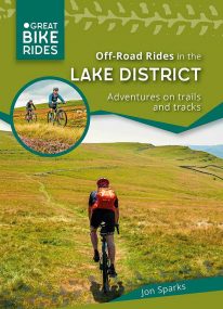 by Jon Sparks The second in a series of themed cycle guides to the Lake District, Off-Road Rides outlines a series of cycle rides filling the often-overlooked gap between easy forest roads and hardcore mountain biking. The routes seek out enjoyable tracks and trails, linked by quiet lanes. They include café and picnic stops, plus points of interest along the way.
 -
Coming Soon
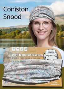
Lake District: Coniston - Neck Gaiter/Scarf/Snood
Wearable large-scale 1:25,000 Ordnance Survey map artwork: Coniston in the Lake District
CONISTON IS ONE OF THE LAKE DISTRICT'S LOVELIEST LAKES. Over five miles long and surrounded by the Cumbrian fells, Coniston is a justified favourite with visitors. The luxurious, silky neck tube features wearable large-scale 1:25,000 Ordnance Survey map artwork. Now you or a friend can own this stylish and permanent souvenir of an iconic part of the English Lake District. Note: While the Ordnance Survey mapping used on the snood is up-to-date at the time of production, it is not recommended for navigation. Walkers should carry the correct OS online or sheet map and compass.Ordnance Survey Licence No.: 0100047867
-
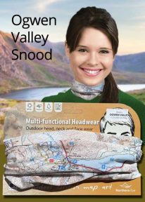
Wales: Tryfan & the Glyders - Neck Gaiter/Scarf/Snood
Wearable large-scale 1:25,000 Ordnance Survey map artwork: Tryfan & the Glyders in Snowdonia
WALES' FAMOUS OGWEN VALLEY is home to the shallow, ribbon lake of Llyn Ogwen (alongside the main A5) , which divides the two main mountain rages of the Snowdonia National Park — the Carneddau and the Glyderau. Key mountains here include mighty Tryfan and the Glyders. This detailed Ordnance Survey mapping snood shows the lake and its dramatic surroundings, making it the ideal present or souvenir for everyone who loves this iconic valley and its surrounding peaks. Note: While the Ordnance Survey mapping used on the snood is up-to-date at the time of production, it is not recommended for navigation. Walkers should carry the correct OS online or sheet map and compass.Ordnance Survey Licence No.: 0100047867
-
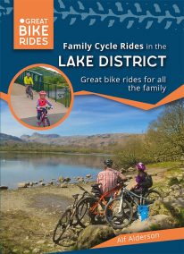 by Alf Alderson As one of the UK’s most beautiful regions it’s no surprise that the Lake Districtis so popular amongst cyclists. It also has a fearsome reputation — climbs such as Honister Pass and Whinlatter Pass are challenging enough to have featured in the Tour of Britain, whilst the grueling combination of Hardknott and Wrynose Passes between Little Langdale and Eskdale offers some of the toughest cycling in the country, with 33 per cent gradients in some places. But the Lake District is not all super-steep hills, fortunately! There are plenty of easy lakeside cycle paths and quiet country lanes, along with the mountain bike centres at Whinlatter and Grizedale, where even the youngest cycling enthusiast can get to know this beautiful landscape. So with a little effort, anyone can access some truly magnificent Cumbrian scenery on their bike
 -

Wales: Cadair Idris - Neck Gaiter/Scarf/Snood
Wearable large-scale 1:25,000 Ordnance Survey map artwork: Cadair Idris in Snowdonia
CADAIR IDRIS IS THE SECOND-HIGHEST MOUNTAIN IN THE SNOWDONIA NATIONAL PARK. Rightly popular with walkers, it stands at the southern end of the National Park near Dolgellau. This detailed Ordnance Survey mapping snood shows the shapely mountain and its three main routes of ascent, making it the ideal present or souvenir for everyone who has climbed, or dreams of climbing, this wonderful summit. Note: While the Ordnance Survey mapping used on the snood is up-to-date at the time of production, it is not recommended for navigation. Walkers should carry the correct OS online or sheet map and compass.Ordnance Survey Licence No.: 0100047867
-
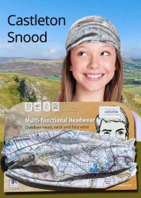
Peak District: Castleton - Neck Gaiter/Scarf/Snood
Wearable large-scale 1:25,000 Ordnance Survey map artwork: Castleton in the Peak District
CASTLETON AND THE GREAT RIDGE LIE AT THE HEART OF THE PEAK DISTRICT. This attractive, silky smooth snood features historic coloured map artwork showing the area in detail. The perfect souvenir or gift. Note: While the Ordnance Survey mapping used on the snood is up-to-date at the time of production, it is not recommended for navigation. Walkers should carry the correct OS online or sheet map and compass.Ordnance Survey Licence No.: 0100047867
-
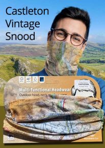
Peak District: Castleton (Vintage) - Neck Gaiter/Scarf/Snood
Wearable large-scale historic map artwork: Castleton in the Peak District
CASTLETON AND THE GREAT RIDGE LIE AT THE HEART OF THE PEAK DISTRICT NATIONAL PARK. The ever-popular town lies between the gentle limestone 'White Peak' to the south, and the starker gritstone 'Dark Peak' to the north. This attractive, silky smooth snood features historic coloured map artwork showing the area in detail. Note: The historic mapping used on this snood is not recommended for navigation. Walkers should carry the correct modern OS online or sheet map and compass. -
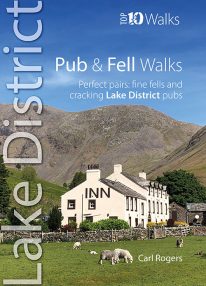 If you like walking up Lakeland's most iconic fells followed by a visit to an excellent and nearby pub or inn, then this is the book for you. Well-known outdoor author Carl Rogers cleverly combines some of Cumbria's finest fell walks with its best-loved pubs. They're a marriage made in heaven — with some super natural pairs such as the Kirkstile Inn at Loweswater with Melbreak literally just behind the pub. Up a fell and down a pint - what could be better?