-
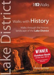 WINNER OF TGO’s ‘BEST GUIDEBOOK’ AWARD 2013 This award-winning book of short circular walks explores the ten most amazing historic sites in the Lake District. It may not seem obvious at first, but the rich human heritage of the area we now call the Lake District is evident all around us as we walk the fells and dales. From the enigmatic monuments built by prehistoric peoples to the industrial scars left in more modern times, centuries of human habitation have left their mark on this landscape. Keep your eyes and your imagination open, and you will come to realise that every step you take is a step through time. A worthy winner.
 -
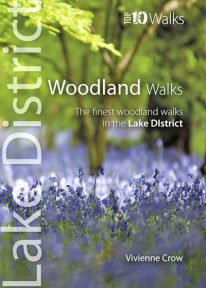 This lovely little book will take you on ten short circular walks through the finest woods and forests in the Lake District People seem to be drawn to trees, be they part of a landscape that has existed for centuries or planted in more modern times. There is something special about being in among their sturdy trunks, surrounded by a rich understorey with the sunlight piercing the canopy high above. In the Lake District, there is a huge variety of woodland — and no matter what their origins, what tree types grow there or how they have been managed, that extraordinary atmosphere never fails to nourish the soul.
 -
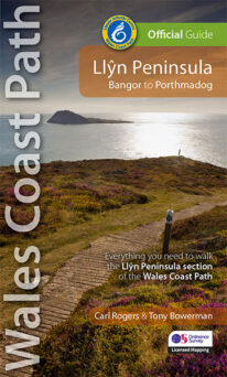 NEW - 4th edition updated and revised – 2023 This Official Guide to the Llŷn Peninsula section of the Wales Coast Path contains everything local and long-distance walkers need. The Llŷn offers some of the finest coastal walking in North Wales. Its distinctive landscape is characterised by traditional farms, compact villages and volcanic hills encircled by the ever-present sea. Along the way, you'll pass Iron Age hillforts, pilgrims' churches, medieval castles, a hidden valley, a pub on the beach, tiny coves, sandy bays and Bardsey island balanced at the tip of this ancient 'Land's End of Wales'. Keep an eye out, too, for seabirds, wild goats, choughs, seals, dolphins, wildflowers and butterflies. The Llŷn coast path really is a walkers' paradise.
 -
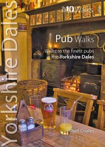 This lovely little book will take you on short circular walks to some of the Yorkshire Dales' most distinctive pubs and inns. The pubs of the Yorkshire Dales reflect both the area and the local people: occasionally gritty and challenging, sometimes uncompromising but essentially hugely welcoming and full of character. Some of England’s best watering holes stand here beside country lanes and village greens as they have for centuries past, gathering and exuding that unique amalgam which defines a pub. The flagged floors, the winter fires, the lamplight pooling onto lanes through bottle-glass windows, the quirky bars; that happy jigsaw of time and place which makes rambling to and between them one of life’s great pleasures.
 -
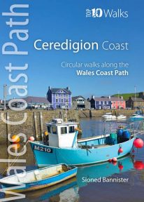 This handy pocket size book will take you on ten of the best short circular walks along the Ceredigion coast. Cardigan Bay embraces the dramatic sweep of the Welsh coastline, from Bardsey Island on the tip of the Llŷn in the north, to Strumble Head in Pembrokeshire in the south. It takes in parts of two National Parks: Snowdonia and Pembrokeshire, and three different counties: Gwynedd, Ceredigion and Pembrokeshire. The southern half of Cardigan Bay covers the rugged coastline between Aberystwyth and Cardigan. The dramatic cliffs and hidden coves are part of the Ceredigion Coast Path: a 60 mile trail that promises stunning views and some of the best opportunities for walkers to spot maritime wildlife in Wales.
 -
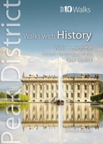 This lovely pocket size book explores ten of the Peak District's most fascinating historic landscapes — from prehistoric monuments to Industrial Revolution ruins. Stone tools from Thor’s Cave indicate that man arrived in the Peak as the glaciers receded. More obvious are Bronze and Iron Age circles, burials and earthworks, as well as the scars of mineral extraction — begun by the Romans and continuing today. Some Peakland churches claim Saxon foundation, and by the Middle Ages there was an extensive network of tracks and settlements. Water powered the first industrial revolution, bringing roads, canals and railways, and in the fine country mansions, farmsteads, cottages and town houses there is a rich variety of vernacular and classic architecture.
 -
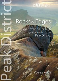 This attractive pocket size book will take you on short circular walks to the ten finest rocks and edges in the Peak District. Surprisingly for newcomers, the Peak District is almost devoid of anything resembling a traditional mountain peak (the name instead derives from the Old English paec, merely meaning ‘hill’). In reality, The Peak is a high, sloping plateau, cleft by deep valleys and winding ravines. In compensation, however, there are long runs of startlingly dramatic cliffs — here known as edges — and spectacularly weathered outcrops of rock, often referred to as tors. For rock climbers, they offer some of England’s finest challenges, while for walkers the views from the escarpments’ rims can be unforgettable.
 -
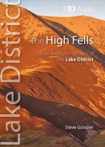 This handy, pocket size book explores ten short circular routes on the best high fells in the Lake District. The Lakeland fells have inspired writers, artists and walkers for centuries. Like the deep valleys that separate them, they were formed by the flow and grind of ancient ice sheets. Above the 2,000-foot contour, they form a high mountain environment whose sheer cliffs, narrow edges, and exposed rocky summits demand respect. Today, this rugged upland landscape is one of the most visited hill walking areas in Britain. The high fells feature enough classic routes, challenges and captivating views to delight even the most demanding fell walker.
 -
Coming Soon
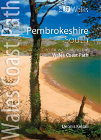 This lovely little book explores the ten best short circular walks along the southern part of the Pembrokeshire coast — itself part of the Wales Coast Path. The Pembrokeshire coast alters subtly from north to south. The southern rocks are far younger and the coast tends to be south-facing, too, creating a gentler hinterland. This influenced historical development and culture, for although the Norman advance extended throughout Pembrokeshire, settlement focused on the more fertile southern corner. It became known as ‘Little England’, with English rather than Welsh spoken, a tradition reflected in place names. Before reliable roads, trade and prosperity favoured the coast, and because the railways came late here, Pembrokeshire was largely ignored by the Industrial Revolution. Unspoiled and breathtakingly scenic, the coast is captivating every step of the way.
 -
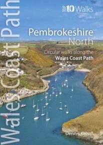 This photogenic book will take you on ten short circular walks along the northern part of the Pembrokeshire section of the Wales Coast Path. Pembrokeshire’s north coast has a rugged and remote quality, reflecting the wildness of the hills that rise behind. It was largely ignored during the Norman colonisation and even today beyond St Dogmael’s there are only a handful of coastal communities. Yet burial cairns, promontory forts and a pre-historic trackway across the Preseli Hills indicate widespread prehistoric settlement, and it was an important focus during the spread of Celtic Christianity. Fishing, farming and stock grazing were traditional ways of life, but the Industrial Revolution briefly opened coastal quarrying and the railway made Fishguard an important Irish port. Today, it is a relative backwater but the coast has an untamed beauty, its flowers, birds, seals and porpoises making it a truly special place.
 -
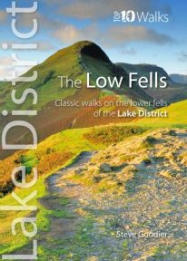 This superb pocket size book will take you on ten short circular walks to the ten best-known low fells in the Lake District The fells get their name from the Old Norse word, fjalls, which originally meant areas of rough upland grazing. Today, the Lakeland fells promise some of the best high level walking in England, and a real sense of freedom. But though the high fells often feature rocky summits, narrow edges and sheer cliffs, the lower fells, below the 2,000 foot contour, are greener, rounder and kinder. Walking on them can still be steep and strenuous, of course, but the routes are more suitable for the general walker. And the views are just as incredible.
 -
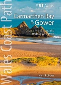 This handy, pocket size book will take you on the ten best short circular walks along the Carmarthen Bay and Gower stretch of the Wales Coast Path. Carmarthen Bay embraces an area of Welsh coast stretching from south Pembrokeshire to the Gower Peninsula. Long, sandy beaches and wide, silty estuaries dominate much of the bay, though there are also high cliffs and rocky coves in places. The Gower Peninsula, at the eastern end of the bay, is a small but priceless gem. Britain’s first official Area of Outstanding Natural Beauty (AONB), the peninsula contains an astonishing variety of landscapes: dunes, marshland, high cliffs, windswept downs, wooded valleys, picturesque villages and glorious sandy beaches — all linked by a superb footpath network.
 -
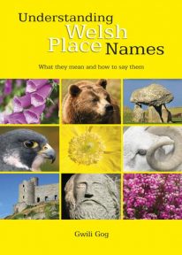 Puzzled by Welsh place names but want to know what they mean and how to say them? This fascinating, easy-to-use guide means non-Welsh speakers can now easily translate and understand place names all over Wales — on the map, on road signs, and out in the countryside. Armed with this insider knowledge, you’ll discover there’s a whole exciting new dimension to the Welsh landscape. In fact, Wales will never be quite the same again ….
 -
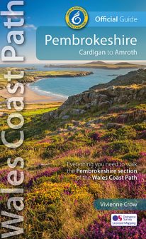 NEW, updated and revised edition - 2021 One of seven Official Guides to the Wales Coast Path The 186 mile/300km long Pembrokeshire section of the Wales Coast Path runs through some of Wales’ most varied and dramatic coastal scenery — high, rugged cliffs and long sandy bays, Pembroke Castle, St David’s cathedral and St Govan’s remote cliff-wrapped chapel, with several large offshore islands. Pembrokeshire is also Britain’s only coastal National Park. This Official Guide splits the route into 14 convenient day sections, each of about 10-17 miles / 16-27 kilometres. It contains everything local and long-distance walkers need to enjoy the path.
 -
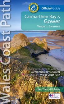 NEW, updated and revised edition - 2021 One of seven Official Guides to the Wales Coast Path The Carmarthen Bay and Gower section of the Wales Coast Path runs for 120 miles/193 kilometres between Amroth, on the eastern edge of the Pembrokeshire Coast National Park, to Swansea, on the landward side of the Gower Peninsula. This Official Guide splits the route into 12 convenient day sections, each of about 10-17 miles / 16-27 kilometres. It contains everything local and long-distance walkers need to enjoy the path and includes: An overview of Carmarthen Bay and Gower with dedicated history and wildlife sections Twelve day-walk sections with detailed route descriptions and full, enhanced Ordnance Survey mapping Distance charts, section overviews, background information and interpretation of places of interest Stunning professional photographs throughout Information on accommodation, public transport, local information, weather, and tidal links.
 -
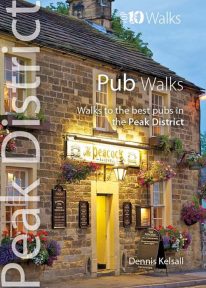 This handy pocket size book will take you on short circular walks to the ten best pubs in the Peak District. Ever since rambling became a recognised pastime, country pubs have been magnets for walkers. Whether a lunch-time stop along the way or a final destination for the day, the promise of a thirst-quenching pint or a hearty meal are, for many, an integral part of the day. Many of Peakland’s inns have their origins in serving the jaggers and stockmen who travelled the lonely upland routes. Today, they serve not only the locals but also the growing influx of recreational visitors. Long live the Peak District pub.
 -
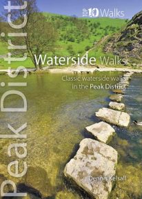 This pocket size book explores the ten best short circular waterside walks in the Peak District. Some follow lovely stretches of rivers; others explore the northern reservoirs. Several major rivers originate in the Peak, fed by countless springs, brooks and streams that have cut deep cloughs and gorges through the grit and limestone. Many powered the early industrialisation of the area while the valleys often served as conduits for trans-Pennine trade. Other dales, too steep or narrow for settlement or farming, or whose streams found subterranean courses, were ignored and today provide valuable wildlife habitats. And although the region has no significant natural lakes, reservoirs abound and are now largely naturalised within the landscape.
 -
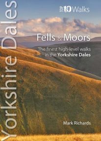 This attractive pocket size book features the ten finest short circular walks on the fells and moors of the Yorkshire Dales. The term ‘fell’ derives from the Norse settlers and was applied here to areas of upland pasture. While the Lake District is defined by its soaring ridges, the Dales, as their name implies, are an intricate pattern of valleys set in a muted moorland landscape. Yet great hills exist — to enthral and enthuse even the most ardent hillgoer. There is no better way of grasping the scale, beauty and extent of the Yorkshire Dales than from this fabulous compact of high fell tops. Each rooted in a dale, each dignified with unique prospects, all meriting walking as a richly rewarding company of hills.
 -
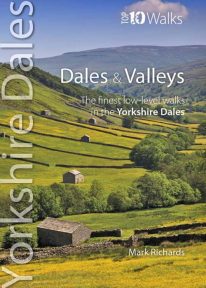 This lovely pocket size book describes the ten best short circular walks in the Yorkshire Dales' dales and valleys. The focus in the Yorkshire Dales tends to be on a trio of much-loved valleys: Swaledale, Wensleydale and Wharfedale. Yet, broadening the gaze, one finds other equally spellbinding valleys, such as Airedale, Ribblesdale, the Rawthey and Dentdale. To the north, the bounding valleys of the Eden and Lune stretch the beauty of the National Park into wider horizons of pastoral serenity. Here are walks for quiet enjoyment and seasonal beauty, where nature still reigns amid traditional patterns of farming practice. Solid stone barns and field walls characterise the dale bottoms; and the flora of the dales is wonderfully diverse: many a meadow retains its native herbal mix — yielding a delightful aroma at haytime.
 -
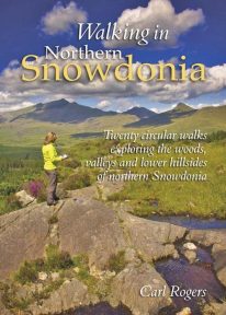 This attractive book explores twenty of the best low level circular walks in northern Snowdonia. Walking in Northern Snowdonia is dedicated to the northern half of the National Park, bounded by the Conwy Valley to the east, Glyn Lledr and the Vale of Ffestiniog to the south and Cwm Pennant to the west. Twenty circular walks are described, ranging in length from 4½ to 9 miles, which explore the woods, valleys and lower hillsides of this unique and beautiful area.
 -
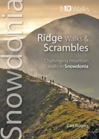 The ten routes outlined in this attractive pocket size book are amongst the very best challenging routes on the mountains of Snowdonia. Snowdonia's mountain ridges can be every bit as dramatic as the summits they connect. Some are well known classics like the Snowdon Horseshoe or Nantlle Ridge, while others are surprisingly well kept secrets like the Llech Du Spur, Gyrn Lâs Ridge or the ridges of the northern Glyderau. Created as a companion volume to the best selling 'Top 10 Mountain Walks', these little books will show you the very best that Snowdonia has to offer.
 -
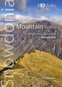 The hills and mountains of Snowdonia will captivate any lover of wild mountain scenery, with around 100 summits above 2,000 feet (approximately 610 metres) and fourteen exceeding 3,000 feet (914 metres). The ten classic walks in this great little guide have been chosen to give a variety of routes, spread across the entire National Park, with most of the main hill groups represented. For each mountain the most scenic route has been chosen and where possible these are well-established, classic paths, easy to follow, with good access and official parking. Enjoy Snowdonia.
 -
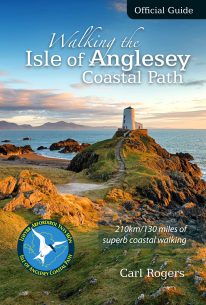 The Official Guide to the Isle of Anglesey/Ynys Mon Coastal Path New Edition - rewalked and wholly updated 2018 The route is described in a clockwise direction, starting and finishing at Holyhead. The 130 mile/210km long Isle of Anglesey Coastal Path passes through some of the grandest coastal scenery in Wales — wide sandy bays and estuaries, intimate coves, dramatic cliffs and rocky islets, sand dunes and forests—much of it designated ‘An Area of Outstanding Natural Beauty (AONB). This Official Guide has been designed to provide all the information needed to plan and walk the coastal path and includes:
- Information on accommodation, public transport, seasonal closures and tidal restrictions
- Twelve day-walk chapter sections with detailed route descriptions and full Ordnance Survey mapping
- Fascinating notes on points of interest
-
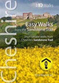 Cheshire’s Sandstone Trail is probably the most popular middle-distance walk in Northwest England. The Trail runs for 55 kilometres/34 miles along Cheshire’s beautiful and varied central sandstone ridge between Frodsham and Whitchurch, just over the border in Shropshire. This cleverly structured and well designed guidebook gives walkers the ten best short circular walks along the length of the Sandstone Trail in a handy, pocketable format.