-
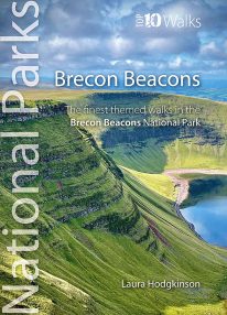 by Laura Hodgkinson This good looking, modern walking book will take you on ten short circular themed walks across South Wales' ever-popular Brecon Beacons National Park. The Brecon Beacons was Britain’s 10th National Park, established in 1957 to preserve and highlight the unique landscape of the area. The Brecon Beacons are said to be named after the historical practice of lighting beacons of fire upon hilltops to forewarn neighbouring valleys of invasion. The Brecon Beacons cover 1,344 square kilometres / 519 square miles with it’s spectacular waterfalls, valleys and expanse of hilly terrain; the Black Mountain to the west, the Fforest Fawr Geopark, Waterfall Country and the Pen y Fan range at the centre, and The Black Mountains to the east. The variety of flora and fauna is as vast as the landscape. Rare sub-arctic, alpine plants thrive within this unique climate. Mammals you're likely to spot include include wild mountain ponies, horseshoe bats, otters and water voles. Often seen birds of prey include the buzzard and iconic red kite. It's a wonderful area for walking and for everyone with a love of the outdoors.
 -
Coming Soon
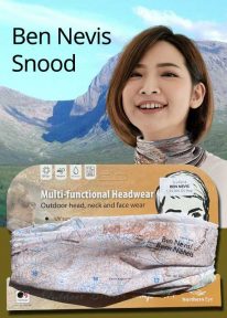
Scotland: Ben Nevis - Neck Gaiter/Scarf/Snood
Wearable large-scale 1:50,000 Ordnance Survey map artwork: Ben Nevis in Scotland
BEN NEVIS IS THE HIGHEST MOUNTAIN IN SCOTLAND AND THE BRITISH ISLES. Rising to 1,345 metres (4,413 ft) above sea level, the summit is reached by around 100,000 visitors a year. This detailed Ordnance Survey mapping snood shows the mountain and its awe-inspiring surroundings, making it the ideal present or souvenir for everyone who loves this most famous of Scotland's mountains. Note: While the Ordnance Survey mapping used on the snood is up-to-date at the time of production, it is not recommended for navigation. Walkers should carry the correct OS online or sheet map and compass.Ordnance Survey Licence No.: 0100047867
-
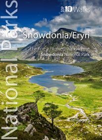 Discover the very best of the dramatic Snowdonia National Park, in North Wales. These ten themed walks will take you to the best and most iconic places across Snowdonia, from the mighty Aber Falls in the north, to Cadair Idris, in the south. Famous for its lofty mountains and open hills, Snowdonia is characterised, too, by dramatic upland lakes and tarns enfolded within glacial troughs and valleys, and short, steep rivers tumbling to the sea. Discover vast empty beaches, friendly pubs and stunning views, hidden lakes and awesome waterfalls, challenging hills and mighty mountains. Every one is a walk to enjoy and savour on the day, and to remember long afterwards.
 -
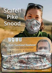
Scafell Pike - Neck Tube/Scarf/Snood
Wearable large-scale 1:25,000 Ordnance Survey map artwork: Scafell Pike in the Lake District
CELEBRATE ENGLAND'S HIGHEST MOUNTAIN and one of the National Three Peaks Challenge summits with this attractive modern Ordnance Survey 1:25,000 scale mapping snood or neck warmer. It looks great and will keep you snug and comfortable on the way up and down. The perfect gift or souvenir for everyone who climbs - or is about to climb - this iconic peak. Note: While the Ordnance Survey mapping used on the snood is up-to-date at the time of production, it is not recommended for navigation. Walkers should carry the correct OS online or sheet map and compass.Ordnance Survey Licence No.: 0100047867
-
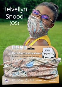
Helvellyn - Neck Gaiter/Scarf/Snood
Wearable large-scale 1:25,000 Ordnance Survey map artwork: Helvellyn in the Lake District
HELVELLYN IS ONE OF THE LAKE DISTRICT'S MOST POPULAR PEAKS at 950 metres / 3,118 feet above sea level. The luxurious, silky neck tube features wearable large-scale 1:25,000 Ordnance Survey map artwork. Now you or a friend can own this stylish and permanent souvenir of an iconic mountain. Note: While the Ordnance Survey mapping used on the snood is up-to-date at the time of production, it is not recommended for navigation. Walkers should carry the correct OS online or sheet map and compass.Ordnance Survey Licence No.: 0100047867
-
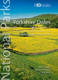 Discover the very best walks in the Yorkshire Dales National Park. These ten themed walks explore the contrasting faces of the Yorkshire Dales — the gentle flower-filled Dales and the wild and rugged uplands with their drystone walls, waterfalls, limestone pavements and iconic peaks. Find unspoiled pubs and friendly teashops. Visit tiny villages, castles, churches and ancient abbeys. Stroll beside crystal rivers or thrill to the thunder of some of Britain’s mightiest waterfalls. Conquer the Three Peaks of Pen-y-ghent, Ingleborough and Whernside. Or just enjoy the quiet countryside and spectacular scenery. Every walk here is a walk to savour.
 -

Snowdon - Neck Gaiter/Scarf/Snood
Wearable large-scale 1:25,000 Ordnance Survey map artwork: Snowdon in Snowdonia
SNOWDON IS THE HIGHEST AND MOST POPULAR MOUNTAIN IN WALES. Also known as 'The Top of Wales', it reaches 1,085 metres (3,560 ft) above sea level. This detailed Ordnance Survey mapping snood shows the summit and six main routes of ascent, making it the ideal present or souvenir for everyone who reaches, or dreams of reaching, the top Note: While the Ordnance Survey mapping used on the snood is up-to-date at the time of production, it is not recommended for navigation. Walkers should carry the correct OS online or sheet map and compass.Ordnance Survey Licence No.: 0100047867
-
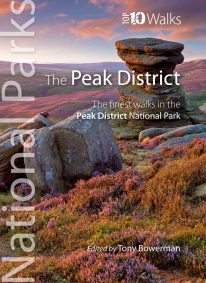 Discover the very best of the Peak District. These ten themed walks explore the contrasting faces of the Peaks — the gentle White and rugged Dark Peak. Discover clear rivers and streams, ancient packhorse bridges and stepping stones. Walk through winding dales and valleys bright with wildflowers. Visit stately Chatsworth or marvel at the panorama from Monsal Head. Tour upland reservoirs and dramatic rocky edges popular with climbers. Slog up Shutlingsloe or explore the open moorland and strangely eroded tors on Kinder Edge. Every one is a walk to remember.