-
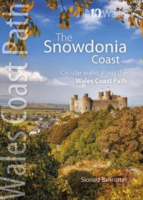 This lovely little book contains the ten best short circular walks along the north part of the Cardigan Bay section of the Wales Coast Path Cardigan Bay embraces the dramatic sweep of the Welsh coastline, from Bardsey island on the tip of Lleyn, in the north, to Strumble Head in Pembrokeshire, in the south. It takes in parts of two National Parks: Snowdonia and Pembrokeshire, and three different counties, Gwynedd, Ceredigion and Pembrokeshire. The striking northern section between Porthmadog and Borth is as varied as it is beautiful. Characterised by vast beaches and rugged cliffs, the coast offers superb walking with ever-changing views and a wealth of wildlife.
 -
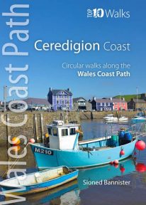 This handy pocket size book will take you on ten of the best short circular walks along the Ceredigion coast. Cardigan Bay embraces the dramatic sweep of the Welsh coastline, from Bardsey Island on the tip of the Llŷn in the north, to Strumble Head in Pembrokeshire in the south. It takes in parts of two National Parks: Snowdonia and Pembrokeshire, and three different counties: Gwynedd, Ceredigion and Pembrokeshire. The southern half of Cardigan Bay covers the rugged coastline between Aberystwyth and Cardigan. The dramatic cliffs and hidden coves are part of the Ceredigion Coast Path: a 60 mile trail that promises stunning views and some of the best opportunities for walkers to spot maritime wildlife in Wales.
 -
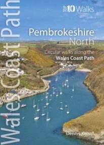 This photogenic book will take you on ten short circular walks along the northern part of the Pembrokeshire section of the Wales Coast Path. Pembrokeshire’s north coast has a rugged and remote quality, reflecting the wildness of the hills that rise behind. It was largely ignored during the Norman colonisation and even today beyond St Dogmael’s there are only a handful of coastal communities. Yet burial cairns, promontory forts and a pre-historic trackway across the Preseli Hills indicate widespread prehistoric settlement, and it was an important focus during the spread of Celtic Christianity. Fishing, farming and stock grazing were traditional ways of life, but the Industrial Revolution briefly opened coastal quarrying and the railway made Fishguard an important Irish port. Today, it is a relative backwater but the coast has an untamed beauty, its flowers, birds, seals and porpoises making it a truly special place.
 -
Coming Soon
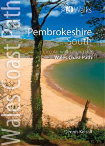 This lovely little book explores the ten best short circular walks along the southern part of the Pembrokeshire coast — itself part of the Wales Coast Path. The Pembrokeshire coast alters subtly from north to south. The southern rocks are far younger and the coast tends to be south-facing, too, creating a gentler hinterland. This influenced historical development and culture, for although the Norman advance extended throughout Pembrokeshire, settlement focused on the more fertile southern corner. It became known as ‘Little England’, with English rather than Welsh spoken, a tradition reflected in place names. Before reliable roads, trade and prosperity favoured the coast, and because the railways came late here, Pembrokeshire was largely ignored by the Industrial Revolution. Unspoiled and breathtakingly scenic, the coast is captivating every step of the way.
 -
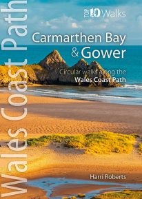 This handy, pocket size book will take you on the ten best short circular walks along the Carmarthen Bay and Gower stretch of the Wales Coast Path. Carmarthen Bay embraces an area of Welsh coast stretching from south Pembrokeshire to the Gower Peninsula. Long, sandy beaches and wide, silty estuaries dominate much of the bay, though there are also high cliffs and rocky coves in places. The Gower Peninsula, at the eastern end of the bay, is a small but priceless gem. Britain’s first official Area of Outstanding Natural Beauty (AONB), the peninsula contains an astonishing variety of landscapes: dunes, marshland, high cliffs, windswept downs, wooded valleys, picturesque villages and glorious sandy beaches — all linked by a superb footpath network.
 -
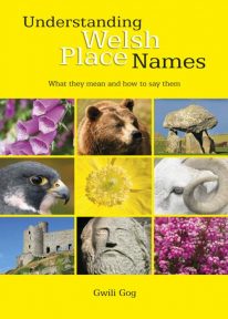 Puzzled by Welsh place names but want to know what they mean and how to say them? This fascinating, easy-to-use guide means non-Welsh speakers can now easily translate and understand place names all over Wales — on the map, on road signs, and out in the countryside. Armed with this insider knowledge, you’ll discover there’s a whole exciting new dimension to the Welsh landscape. In fact, Wales will never be quite the same again ….
 -
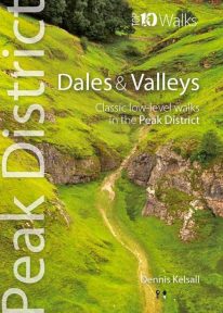 This attractive pocket size book gives you the ten very best dale and valley walks in the Peak District. The White Peak is known for dramatic limestone gorges: convoluted pathways carved into its heart, where rearing pinnacles, dark caves and thundering rivers struck awe into seventeenth-century travellers. Still captivating today, they harbour rich woodland, wildflower meadows and disappearing and resurgent streams, one of the area’s strangest curiosities. Delightful Dovedale, once the haunt of the renowned anglers Izaak Walton and Charles Cotton, contrasts with Cave Dale, a gaunt, dry passage below Castleton’s Norman stronghold. But the Dark Peak has attractive valleys too, and different again is the Dane Valley, which cuts onto the Cheshire Plain from the gritstone moors.
 -
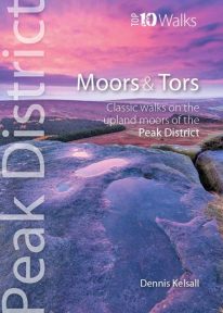 This lovely, pocket size book offers the ten best short circular walks to upland moors and tors across the Peak District. The uplands of the Peak bear the characteristics of hills rather than mountains: high, undulating plateaux dissected by deep, meandering valleys. Yet there is little uniformity; the seemingly remote moorland of the Kinder plateau is in sharp contrast to the gentler and lower upland heaths found farther south. These landscapes change subtly with the seasons and, for those who care to look, are rich in wildlife. There are birds, hares, and foxes; and in summer, adders and lizards bask in the sun while butterflies dance in the remotest places.
 -
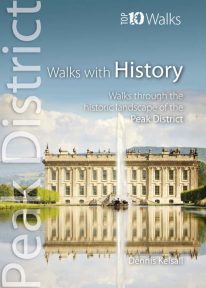 This lovely pocket size book explores ten of the Peak District's most fascinating historic landscapes — from prehistoric monuments to Industrial Revolution ruins. Stone tools from Thor’s Cave indicate that man arrived in the Peak as the glaciers receded. More obvious are Bronze and Iron Age circles, burials and earthworks, as well as the scars of mineral extraction — begun by the Romans and continuing today. Some Peakland churches claim Saxon foundation, and by the Middle Ages there was an extensive network of tracks and settlements. Water powered the first industrial revolution, bringing roads, canals and railways, and in the fine country mansions, farmsteads, cottages and town houses there is a rich variety of vernacular and classic architecture.
 -
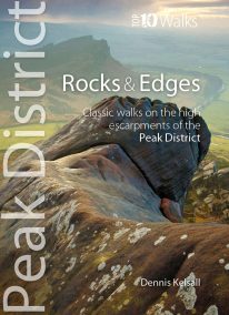 This attractive pocket size book will take you on short circular walks to the ten finest rocks and edges in the Peak District. Surprisingly for newcomers, the Peak District is almost devoid of anything resembling a traditional mountain peak (the name instead derives from the Old English paec, merely meaning ‘hill’). In reality, The Peak is a high, sloping plateau, cleft by deep valleys and winding ravines. In compensation, however, there are long runs of startlingly dramatic cliffs — here known as edges — and spectacularly weathered outcrops of rock, often referred to as tors. For rock climbers, they offer some of England’s finest challenges, while for walkers the views from the escarpments’ rims can be unforgettable.
 -
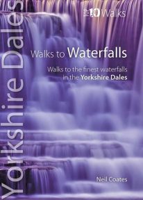 This pretty little book gives you short circular walks to the most spectacular waterfalls in the Yorkshire Dales. Geology and the way it shapes the land have created a countryside tailor-made for the development of waterfalls. The gritstone fells and moors gather copious rainfall, which they shed along countless becks and rivers that erode the rock into twisting gills and valleys. Where localised geological conditions bring together the grits and limestones, differential erosion creates bands of resistant rocks over which the becks plunge as hidden cataracts and waterfalls, often called forces in the Yorkshire Dales. Each has its own unique form and atmosphere to discover and explore.
 -
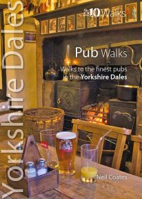 This lovely little book will take you on short circular walks to some of the Yorkshire Dales' most distinctive pubs and inns. The pubs of the Yorkshire Dales reflect both the area and the local people: occasionally gritty and challenging, sometimes uncompromising but essentially hugely welcoming and full of character. Some of England’s best watering holes stand here beside country lanes and village greens as they have for centuries past, gathering and exuding that unique amalgam which defines a pub. The flagged floors, the winter fires, the lamplight pooling onto lanes through bottle-glass windows, the quirky bars; that happy jigsaw of time and place which makes rambling to and between them one of life’s great pleasures.