-
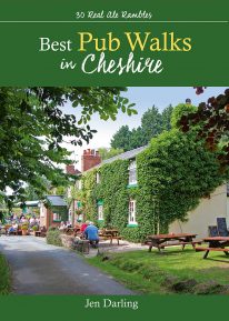 by Jen Darling CHESHIRE IS WELL KNOWN for both its beautiful countryside and its country pubs. This fully revised and updated, 3rd edition of a classic guide book combines the two with superb walks through varied countryside, each one visiting a walker-friendly pub that is well known for its food and drink. The 220-page book ideal for those with a connoisseur’s interest in Real Ale, and for walkers wanting a convenient starting point and route directions - plus some of the best pub lunches in Cheshire. There are 30 circular walks included, covering the entire county from west to east and north to south. Each walk is graded in terms of mileage and difficulty — so families with young children can choose the easy ones, and enthusiasts can find more challenging routes to work up a thirst!
 -
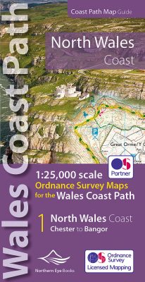 Enhanced, large scale (1: 25,000) Ordnance Survey mapping in a handy atlas format with all the mapping you need to walk a complete North Wales Coast section of the Wales Coast Path. Continuous OS mapping covering the complete route from Chester to Bangor, on the Menai Strait. Contains generous coastal extracts from large-scale OS Explorer maps 266, 265, 264 and OL17. The North Wales Coast Ordnance Survey mapping book is part of a series of map atlases covering the whole of the 870-mile long Wales Coast Path. The enhanced OS 1:25,000 maps are accurate, up-to-date and reliable. Additional map symbols show tea shops, cafes, extra parking, and public toilets. A brief introduction to the North Wales Coast includes a fascinating photo mosaic highlighting notable views, places of interest and wildlife you'll meet along the way. There is also a section of detailed Useful Information at the back of the atlas. Laminated flapped covers showing Wales Coast Path signs and waymarkers, route details and map symbols make these atlases simple and easy to use. The map books’ dimensions are 215mm x 107mm and they fit easily into a standard map pocket.
- Large scale Ordnance Survey Explorer mapping for the complete North Wales Coast in a handy atlas format.
- Highlighted official route of the Wales Coast Path.
- On-map symbols showing amenities at main towns and villages.
- Introduction with attractive photo mosaic.
- Additional useful information
-
 Even the Peak District's name conceals a mystery. Forget the obvious: a visitor expecting towering peaks will be disappointed, as the name comes from the Pecsaetan tribe who once lived here. But there’s a twist: the Anglo-Saxon means “settlers of the Pec”…and that word pec has the same root as our peak, the dialect pike and the Pyrenean pic. So, ultimately, the Peak District is named after its peaks, after all. The Peak District is broadly defined by the conurbations at its corners: Manchester, Sheffield, Derby and Stoke. Within this rectangle, the National Park forms a rough oval of around 550 square miles. The area is traditionally divided into the Dark Peak – peat moorland edged by gritstone, with rugged villages in the valleys — and the softer White Peak - upland pastures defined by drystone walls, divided by gorges and limestone villages. The eastern and western moors are similar to the Dark Peak, but have their own subtly distinctive characters. The Peak District was occupied by humans long before the Pecsaetans and in each era man has left his mark, from prehistoric standing stones and rock art, through the folk legends, crosses and churches of the Middle Ages, to post-medieval follies and puzzling relics of the extraction of lime and lead. The varied geology of the area throws up natural curiosities too: its dark gritstone has wind-sculpted tors and edges, while its gleaming limestone hides caves and subterranean rivers. This handy pocket size book will take you on short circular walks to the ten most fascinating, odd or strange places in the Peak District. Prepare to be amazed and surprised.
 -
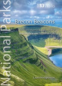 by Laura Hodgkinson This good looking, modern walking book will take you on ten short circular themed walks across South Wales' ever-popular Brecon Beacons National Park. The Brecon Beacons was Britain’s 10th National Park, established in 1957 to preserve and highlight the unique landscape of the area. The Brecon Beacons are said to be named after the historical practice of lighting beacons of fire upon hilltops to forewarn neighbouring valleys of invasion. The Brecon Beacons cover 1,344 square kilometres / 519 square miles with it’s spectacular waterfalls, valleys and expanse of hilly terrain; the Black Mountain to the west, the Fforest Fawr Geopark, Waterfall Country and the Pen y Fan range at the centre, and The Black Mountains to the east. The variety of flora and fauna is as vast as the landscape. Rare sub-arctic, alpine plants thrive within this unique climate. Mammals you're likely to spot include include wild mountain ponies, horseshoe bats, otters and water voles. Often seen birds of prey include the buzzard and iconic red kite. It's a wonderful area for walking and for everyone with a love of the outdoors.
 -
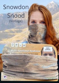
Snowdon - Neck Gaiter/Scarf/Snood
Wearable large-scale historic (1912) map artwork: Snowdon in Snowdonia
SOMETIMES CALLED 'THE TOP OF WALES', Snowdon is the highest and best-known peak in the country, reaching 1,085 metres (3,560 ft) above sea level. This historic, 1912 Ordnance Survey map snood shows the summit and all six main paths up, making it the ideal gift or souvenir for mountain fans everywhere. Note: The historic mapping used on this snood is not recommended for navigation. Walkers should carry the correct modern OS online or sheet map and a compass. -
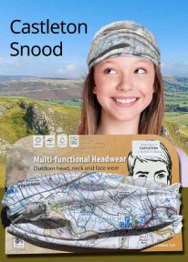
Peak District: Castleton - Neck Gaiter/Scarf/Snood
Wearable large-scale 1:25,000 Ordnance Survey map artwork: Castleton in the Peak District
CASTLETON AND THE GREAT RIDGE LIE AT THE HEART OF THE PEAK DISTRICT. This attractive, silky smooth snood features historic coloured map artwork showing the area in detail. The perfect souvenir or gift. Note: While the Ordnance Survey mapping used on the snood is up-to-date at the time of production, it is not recommended for navigation. Walkers should carry the correct OS online or sheet map and compass.Ordnance Survey Licence No.: 0100047867
-
Coming Soon
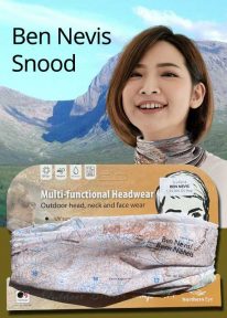
Scotland: Ben Nevis - Neck Gaiter/Scarf/Snood
Wearable large-scale 1:50,000 Ordnance Survey map artwork: Ben Nevis in Scotland
BEN NEVIS IS THE HIGHEST MOUNTAIN IN SCOTLAND AND THE BRITISH ISLES. Rising to 1,345 metres (4,413 ft) above sea level, the summit is reached by around 100,000 visitors a year. This detailed Ordnance Survey mapping snood shows the mountain and its awe-inspiring surroundings, making it the ideal present or souvenir for everyone who loves this most famous of Scotland's mountains. Note: While the Ordnance Survey mapping used on the snood is up-to-date at the time of production, it is not recommended for navigation. Walkers should carry the correct OS online or sheet map and compass.Ordnance Survey Licence No.: 0100047867
-
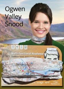
Wales: Tryfan & the Glyders - Neck Gaiter/Scarf/Snood
Wearable large-scale 1:25,000 Ordnance Survey map artwork: Tryfan & the Glyders in Snowdonia
WALES' FAMOUS OGWEN VALLEY is home to the shallow, ribbon lake of Llyn Ogwen (alongside the main A5) , which divides the two main mountain rages of the Snowdonia National Park — the Carneddau and the Glyderau. Key mountains here include mighty Tryfan and the Glyders. This detailed Ordnance Survey mapping snood shows the lake and its dramatic surroundings, making it the ideal present or souvenir for everyone who loves this iconic valley and its surrounding peaks. Note: While the Ordnance Survey mapping used on the snood is up-to-date at the time of production, it is not recommended for navigation. Walkers should carry the correct OS online or sheet map and compass.Ordnance Survey Licence No.: 0100047867
-
Coming Soon
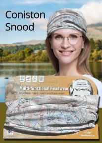
Lake District: Coniston - Neck Gaiter/Scarf/Snood
Wearable large-scale 1:25,000 Ordnance Survey map artwork: Coniston in the Lake District
CONISTON IS ONE OF THE LAKE DISTRICT'S LOVELIEST LAKES. Over five miles long and surrounded by the Cumbrian fells, Coniston is a justified favourite with visitors. The luxurious, silky neck tube features wearable large-scale 1:25,000 Ordnance Survey map artwork. Now you or a friend can own this stylish and permanent souvenir of an iconic part of the English Lake District. Note: While the Ordnance Survey mapping used on the snood is up-to-date at the time of production, it is not recommended for navigation. Walkers should carry the correct OS online or sheet map and compass.Ordnance Survey Licence No.: 0100047867
-
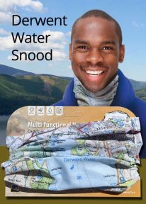
Lake District: Derwentwater - Neck Gaiter/Scarf/Snood
Wearable large-scale 1:25,000 Ordnance Survey map artwork: Derwentwater in the Lake District
DERWENT WATER IS ONE OF THE LAKE DISTRICT'S MOST POPULAR LAKES. Surrounded by fells, the island-dotted lake is three miles long and lies just to the south of Keswick. This luxurious, silky neck tube features wearable large-scale 1:25,000 Ordnance Survey map artwork of the lake and its beautiful shore. Now you or a friend can own this stylish and permanent souvenir of an iconic part of the English Lakes. Note: While the Ordnance Survey mapping used on the snood is up-to-date at the time of production, it is not recommended for navigation. Walkers should carry the correct OS online or sheet map and compass.Ordnance Survey Licence No.: 0100047867
-
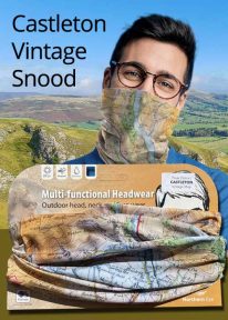
Peak District: Castleton (Vintage) - Neck Gaiter/Scarf/Snood
Wearable large-scale historic map artwork: Castleton in the Peak District
CASTLETON AND THE GREAT RIDGE LIE AT THE HEART OF THE PEAK DISTRICT NATIONAL PARK. The ever-popular town lies between the gentle limestone 'White Peak' to the south, and the starker gritstone 'Dark Peak' to the north. This attractive, silky smooth snood features historic coloured map artwork showing the area in detail. Note: The historic mapping used on this snood is not recommended for navigation. Walkers should carry the correct modern OS online or sheet map and compass. -

Wales: Cadair Idris - Neck Gaiter/Scarf/Snood
Wearable large-scale 1:25,000 Ordnance Survey map artwork: Cadair Idris in Snowdonia
CADAIR IDRIS IS THE SECOND-HIGHEST MOUNTAIN IN THE SNOWDONIA NATIONAL PARK. Rightly popular with walkers, it stands at the southern end of the National Park near Dolgellau. This detailed Ordnance Survey mapping snood shows the shapely mountain and its three main routes of ascent, making it the ideal present or souvenir for everyone who has climbed, or dreams of climbing, this wonderful summit. Note: While the Ordnance Survey mapping used on the snood is up-to-date at the time of production, it is not recommended for navigation. Walkers should carry the correct OS online or sheet map and compass.Ordnance Survey Licence No.: 0100047867
-
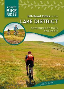 by Jon Sparks The second in a series of themed cycle guides to the Lake District, Off-Road Rides outlines a series of cycle rides filling the often-overlooked gap between easy forest roads and hardcore mountain biking. The routes seek out enjoyable tracks and trails, linked by quiet lanes. They include café and picnic stops, plus points of interest along the way.
 -
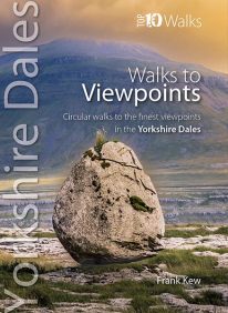
The Yorkshire Dales' Finest Views
Many memories of walks in the Dales are distilled into the fine views one experiences, and it would be a mistake to assume that great views necessarily entail sustained climbs up to the top of the nearest fells. As Wordsworth would have it, one might be ‘surprised by joy’ when coming out of a belt of woodland into fields, or onto the edge of a limestone outcrop, or discovering a hidden valley. Finding a contouring path with a panorama of the bucolic dale below slowly unfolding is so rewarding, as is contemplating the changes of light as the shadows of clouds play upon the wide open moorlands so characteristic of the Yorkshire Dales. The underlying geology, mainly of gritstone and limestone, give rise to different farming practices and other land use which, in turn, provide different vistas and experiences for the walker. Classic Dales’ scenery of limestone pavements, scars and screes features strongly as do the atmospheric limestone gorges formed by glacial action. The two main upland glacial lakes in the Dales and their associated wetlands also feature, as do some lovely riverside strolls through flower-rich meadows. These walks reflect the variety of scenery in the landscapes of the Yorkshire Dales. They are also an invaluable guide to the best views and locations for the keen photographer. Enjoy! -
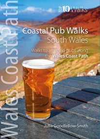
South Wales' best coastal pub walks
This pocket-sized guide gives walkers ten easy, circular walks to amazing coastal pubs along the South Wales section of the Wales Coast Path. With clear information, an overview and introduction for each walk, expertly written numbered directions, large scale Ordnance Survey maps, superb eye-grabbing panoramic photographs, and interpretation of points of interest along the way, these guides set a new standard in clarity and ease-of-use. Each of the short circular walks has been selected for both the quality of the pub and the walk itself. The routes cover the very best walking country in the area. All are in landscapes with particular historical or wildlife interest, and all follow part of the Wales Coast Path. -
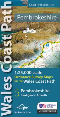 Enhanced, large scale (1: 25,000) Ordnance Survey mapping in a handy atlas format with all the mapping you need to walk a complete Pembrokeshire coast section of the Wales Coast Path. Continuous OS mapping covering the complete route from St Dogmael's near Cardigan to Amroth, on the Carmarthenshire border. Contains generous coastal extracts from large-scale OS Explorer maps OL 35 and OL36. The Pembrokeshire Coast Ordnance Survey mapping book is part of a series of map atlases covering the whole of the 870-mile long Wales Coast Path. The enhanced OS 1:25,000 maps are accurate, up-to-date and reliable. Additional map symbols show tea shops, cafes, extra parking, and public toilets. A brief introduction to the Pembrokeshire Coast includes a fascinating photo mosaic highlighting notable views, places of interest and wildlife you'll meet along the way. There is also a section of detailed Useful Information at the back of the atlas. Laminated flapped covers showing Wales Coast Path signs and waymarkers, route details and map symbols make these atlases simple and easy to use. The map books’ dimensions are 215mm x 107mm and they fit easily into a standard map pocket.
- Large scale Ordnance Survey Explorer mapping for the complete North Wales Coast in a handy atlas format.
- Highlighted official route of the Wales Coast Path.
- On-map symbols showing amenities at main towns and villages.
- Introduction with attractive photo mosaic.
- Additional useful information
-
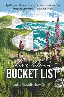 by Julia Goodfellow-Smith 2023's stand-out new personal development book. Live Your Bucket List: Simple steps to ignite your dreams, face your fears and lead an extraordinary life – starting today, uses the author’s personal experiences to provide insight into achieving a specific bucket list dream. Instead of reinventing the wheel, readers can learn from Julia’s mistakes and triumphs to make their own bucket list adventure the best possible success. FREE - Download your free 'Live Your Bucket List' templates: charts, diagrams & certificates
 -
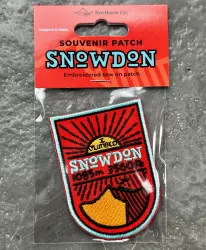 If you've ever climbed Snowdon/Yr Wyddfa (or even just dream of climbing Snowdon) - Wales' highest mountain - then this stylish, superb quality sew-on embroidered patch makes a great souvenir, keepsake or gift.
- Eye-catching, modern design
- Full colour
- Embroidered
- 80mm high
- Contrasting stitched edge
- Colourfast and washable
- Designed in Wales